Wednesday, October 5, 2011

Budawangs


The original intention for this walk was to follow a long used track starting at the Endrick River entrance on the western side of the Budwangs area of Morton National Park. However, this entailed crossing private property and the owner has recently blocked access. So an alternative from the same starting spot was taken, via the Alum Track. It is written up in a guidebook and although part was marked on the map as a route; I assumed that plenty of walkers would have gone this way and a reasonably easy to follow pad, possibly with markers would be there. No sign of a pad existed when we reached the Flat Top Mountain area, so we followed the notes to the top where the view down to Running Creek was enough to cause serious doubts about heading to an area of several creek crossing with unknown scrub. The guide book did mention open sections, but they have either overgrown or we could not locate them; except for a very short wet one. The scrub at the creeks was thick and slowed our progress down even more. Several heathy sections were easy enough to negotiate by weaving through the most open bits. Fortunately when we reached the Square Top Track it was not long before we reached an upper tributary of Running Creek that was living up to the name. A nice clearing was close by too, so we were able to set up camp and cook before dark set in.
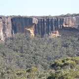
It was over 2.5 k to the junction with main track near the Foster Mountain turnoff. We climbed Foster, where we got the first views of the cliffs of the mountains of the Budwangs. The previous day was mostly fine, except when a period of showers arrived during the afternoon, but today and the next two were delightfully sunny and mild. Back on the track it became narrow and at times there was a bit of scrub ducking and weaving, plus a couple of scrubby creek crossing. For most of the afternoon we were out on plains with a number of tree belts and the views were superb. The cliffs of Mount Hoddle were impressive with huge cave like chunks within them, whist Quiltys and Sturgiss Mountains were equally dramatic.
 
 
The campsites at Styles Creek were described as a bit degraded, but perhaps they now get less use, for they seemed in good order. Perhaps this and time may have healed things. The track from there north was better than what we had been on the previous day, until we encountered lots of fallen trees. Hidden Valley was the first diversion for the day and this was a track that wound a way through a gap in Sturgiss Mountain to a small valley surrounded by cliffs. Our notes indicated that a track should continue through to a clearing, but we found it took a while to find the last bit of pad and were unable to locate any clearing amongst the scrubby interior. On the other hand the pad to the aboriginal Bora ground on Quiltys Mountain was quite obvious and easy to follow. From here we also had views down the valley of the Kilpatrick Creek to Pigeon House Mountain and the huge buttresses of the mountains in that direction.
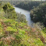
A wide track through forest was followed through The Vines region to meet the first crossing of the Endrick River after which a suitable campsite was found. The final day was a three hour walk with an ever widening valley and plenty of flowers to the second crossing of the Endrick and then a short walk to the car.
 
Photo album Part  2
 
Budawangs Part 2 Styles Creek to Endrick River


Monday, September 19, 2011

Kangaroo Island and The Mallee


Kangaroo Island

Cape Borda

We heard the wind howling during the night at Cape Jervis and were a little worried about the crossing to Kangaroo Island, however the trip over was not too bad at all. On the north coast is Stoke Bush Garden and it a most pleasant couple hours was spent there. Our stop for the night was at a cottage at Cape Borda lighthouse station where we had the place to ourselves.

Ravine des Casoars

The western end of Kangaroo Island had been ravaged by fire in 2007 and prolific regrowth was everywhere, including our Ravine des Casoars walk.
Ravine des Casoars


Flinders Chase

Another historic cottage was used for the next three nights,; in this case the diminutive Postmans Cottage in Flinders Chase NP. A morning walk was made to Rocky River followed by an afternoon to the lower part of the river where it entered the Southern Ocean. This was quite a photogenic walk with the river having many rock features and flowers.
The popular features of Admirals Arch, with lots of seals, and Remarkable Rocks were visited late in the afternoon.
Rocky River

Hanson Bay

Our longest walk on Kangaroo Island was in the Kelly Hill Reserve through nice bushland to Grassland Lakes and onto Hanson Bay.
Hanson Bay

Murray Lagoon

To start with this walk on the way to catch the ferry at Penneshaw looked like it might be quite uninteresting, because of the farm like start, but flowers and close views to the birds (mostly swan) on the lagoon lifted it somewhat.
Murray Lagoon


Mallee Country

Gluepot and Hattah Kulkyne

The hills of the Fleurieu Peninsula included a stop at Hanhdorf before they suddenly ended with a view of flat plains. A stop for a couple of nights in the mallee at the bird reserve at Gluepot and then over the mallee country at Hattah Kulkyne in Victoria for a night there. From there it was the long drive to Canberra.


Mallee Country


Thursday, September 8, 2011

On to South Australia

Lower Glenelg (in Victoria near border)

Although a fairly quite road between Portland and Nelson, it has huge areas of pine plantations and quite a number of log trucks as a consequence. The pines have replaced the native bush, which is sad to see, and some have escaped into the national parks.
The walk along the cliff top of the Glenelg River was pleasant with several sections of large cliff. I was sure the walk started off in an easterly direction, so that is the way we went. There were good cliffs and views, but after a while we couldn’t match the scene to the book and on reaching a 4wd track realised that we went the wrong way. We walked back along the 4wd to the start and then commenced in the correct direction for the walk to the Glenelg River Gorge. We decided that the scenery was just as good the original way, so we had a better walk by seeing the two sections of river.
Lower Glenelg


Cananda and Little Dip

From Nelson it was not that far to drive to reach Mount Gambier in South Australia, where we were surprised by the size of Blue Lake. It is quite a sizeable old crater, certainly a lot bigger that the ones we visited in Victoria. It was a windy day and there always seemed to be rain up ahead, but fortunately it kept moving ahead faster than us. A walk around Cape Buffon was quite interesting with the distorted weather worn coastal rock stacks and undercut cliffs. Next up came Little Dip and a circuit walk of Freshwater Lake. It seems that the Parks Service and the Friends of Little Dip lost enthusiasm for the track as it was very overgrown. The night was spent in Robe, which has quite a few heritage buildings, but it started to rain heavily and we had to be content with viewing them from the car.
Canunda Little Dip

Coorong
North of Robe is the Coorong and here we visited some lakes and after that drove on to Victor Harbour for the night; an obviously popular seaside holiday and retirement town.
Coorong

Deep Creek
In very nice weather we spent a few hours in a walk in Deep Creek. The flora was quite spectacular along the track to Deep Creek Cove.
Deep Creek


Sunday, September 4, 2011

South Western Victoria


On approaching Hamilton many of the farms had dry rock walls surrounding paddocks, rather than wire fences; it was amazing the work that must have gone in to it.
First walk was to Mount Napier, which is the site of a volcano and at the summit there is the remains of the crater. More impressive though was Budj Bim also known as Mount Eccles National Park, for here one of the craters is filled with the waters of Lake Surprise and as well there are old lava canals snaking over the land.
A photo album of the Budj Bim park
Budj Bim - Mount Eccles

We arrived on the coast at Portland, and not far from there is the Cape Nelson State Park. On driving there the first dramatic feature was the numerous wind turbines right up to the boundary of the reserve. Once we started walking the swishing sound of the turbines was quite noticeable; at first we thought it was a plane flying over. The walk was a circuit through the mallees to the cliff edge then along the edge to a lighthouse. The track continued on before crossing through a tunnel of vegetation back to the car.
A photo album of the Cape Nelson park

Cape Nelson